Council approves purchase of 155 acres in Pulaski

By WILLIAM PAINE
Patriot Publishing
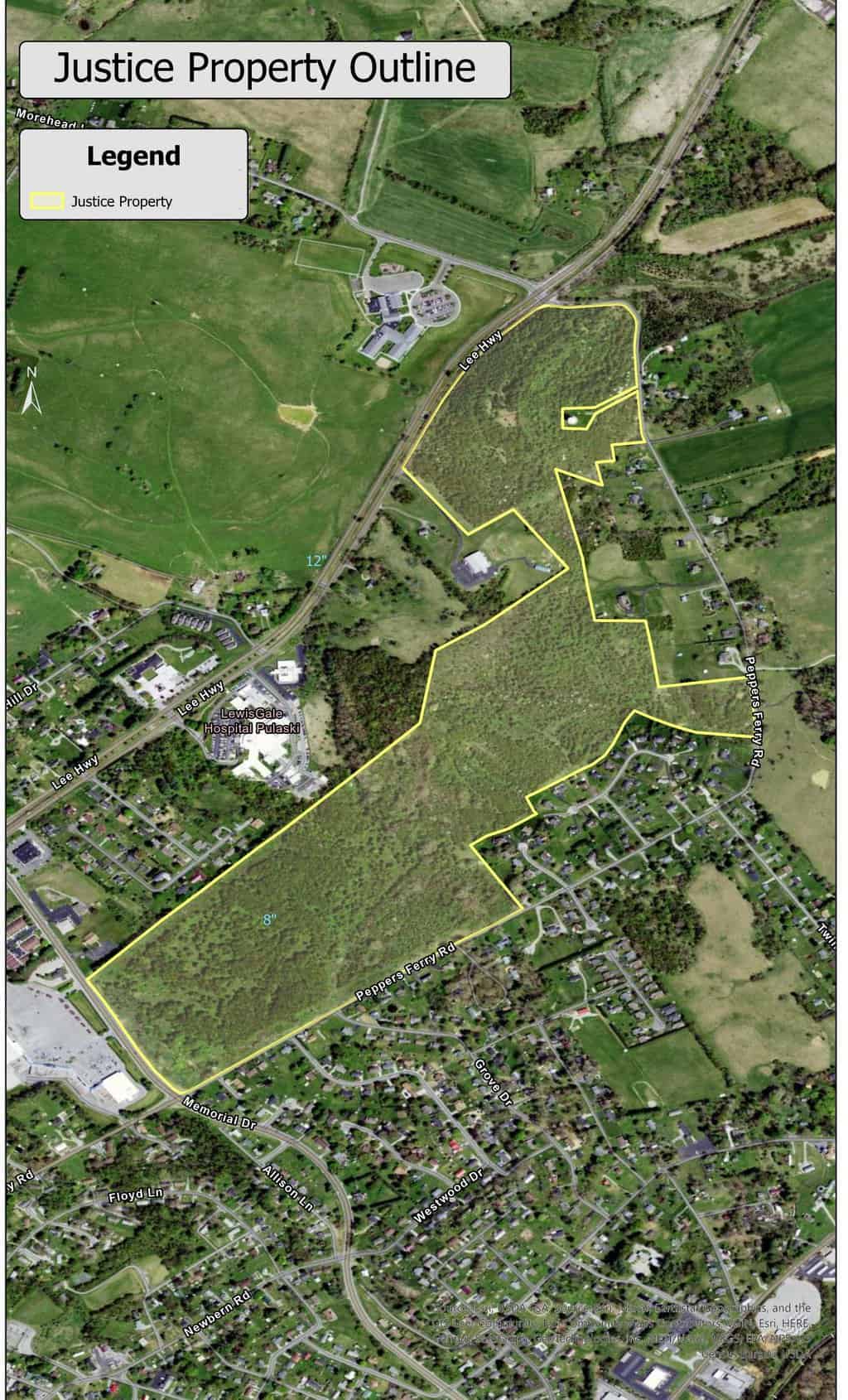
The Pulaski Town Council agreed to purchase 155 acres of land within the town limits of Pulaski for the price of $1.2 million.
The property, which had been owned by West Virginia Governor Jim Justice, was put on the market in November 2023.
At the Town Council’s first meeting in November, a motion was made to give Town Manager Darlene Burchum the authority to draw up a contract for the purchase of this property. All council members voted in favor of the motion except Councilman Greg East, who voted nay.
The 155 acres of undeveloped land lies across from Memorial Square and behind LewisGale Hospital Pulaski, bordering Memorial Drive and several sections of Pepper’s Ferry Road, extending all the way to Lee Highway.
The deal for the purchase of the land was finalized on Thursday Dec. 14, 2023.
When asked why town leadership decided to purchase the property, Town Manager Darlene Burcham replied.
“We want the town to grow and to be able to make the town grow, we have to put that 155 acres to work, either as commercial property or residential property,” said Burcham. “It’s sitting there unimproved and has been for years.”
According to town officials, the purchase for $1.2 million was made possible through the growth of the town’s General Fund undesignated fund balance over the last several years. So, no debt was issued in making this purchase.
How this large swath of undeveloped land will be purposed is, as yet, undetermined.
“We will hire a consultant to do a master plan for the acreage involved,” said Burcham. “I expect that would take 12 to 18 months for decisions to be made about how they would want that property to be developed.”
“Generally, you would do a master plan, to decide what portions of the property you want developed in a certain way,” Burcham continued. “You need to decide if you need more of X or more of Y and then based on that master plan, you go out looking for a developer.”
The town will soon issue a Request for Proposals (RFP) for a consultant firm to complete a master plan for the property. This will subsequently be presented to the council for their approval but this will not likely take place until sometime in 2026.
This 155-acre property is one of the largest tracts of undeveloped land within the town limits and lies mostly within the confines of a residential section of town. The topography of the property contains many dips and rises with its highest point reaching 2143 in elevation near its border at Lee Highway. The Tax map ID number for this parcel is 063- 42- 1063- 42- 1 and can be viewed on the Pulaski County Treasurer’s website.
When the master plan is completed and approved, Town officials believe developers and investors will be attracted to this centrally located property and this will, in turn, increase the town’s tax base by providing new residences, businesses and jobs to the community.
According to a statement provided by the Town of Pulaski, “The council is thrilled to have this opportunity to invest in the town’s future.”


January 5, 2024 @ 11:04 am
This town can’t take care of what it has now purchased 155 acres more undeveloped land.Finish sidewalks and STREETS H20 lines Darlene strikes before leaving GOOD Ridense
January 8, 2024 @ 1:36 pm
You did notice the vote was unanimous other than ONE council member, right? It’s a great idea and could generate millions of dollars over the years for the town. Maybe rather than spurting off a bad attitude, look for the possibilities this will bring.
If my memory serves me, this same parcel (along Memorial Drive) was supposed to be home to the Super Walmart that wound up going to Dublin (as did the ABC store). Why did it go there? Due to people who whined and complained they didn’t want it here. Then they whined and complained when the businesses that depended on the Walmart traffic either had to close or moved closer to Dublin with it. What happened? MORE complaining because now there was “nowhere to shop in Pulaski”.
Can’t win with doom and gloomers. I don’t know how the town managers and council members put up with it.
January 5, 2024 @ 12:24 pm
Maybe the property could be used for affordable housing and small apartment like houses built on one level for senoir citizens and retired people. Also a nice park for the children to play and have fun. Maybe a small walking trail.
January 5, 2024 @ 9:40 pm
This appears to be a paramedic purchase by the town of Pulaski that could substantially enhance the site’s marketability by showing potential entrepuniers / deelopers the property’s potentials while underscorings the town preferences. More communities should take this approach for guiding the future of important properties in their communities Also, this opens up the potential for a public/ private sector development project.
January 8, 2024 @ 1:38 pm
Yes!
January 11, 2024 @ 7:31 pm
Mr. Jim Justice is laughing all the way home to put that money in his kitty to run for the U.S. Senate as a Democrat. He lives just North of me in the panhandle of W.Va. and is finishing his term as the governor of the State of W.Va. Gas in W.Va. is higher than Virginia and they have taken years to widen Interstate 81 to three lanes. Do we get to travel on three lanes. NO! H. Jack Turner
January 14, 2024 @ 8:05 am
A lifelong resident of the town. Very discouraging that you travel to shop. While businesses are located in Pulaski, many are nothing more than junk stores housed in falling down structures. As a kid, I can remember how Main Street used to be. Been sad for years. One of the issues with Pulaski is lack of allowing the town to thrive. Old money and those who have choked the life out of it. Majority should always rule in decision making. Stop letting the voice of a sad few dictate the towns future!
January 14, 2024 @ 4:50 pm
Town needs no more parks. Take care of 6th street and Dora Highway. Put funds into existing parks instead of creating more.